I hope you’re still with me on this journey! I know I don’t have many followers who are interested (not that many read the blog now).
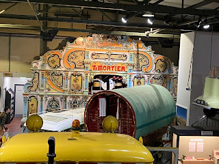
We are travelling through the Grampian mountains to get to Inverness but after leaving Aberdeen I saw signs when travelling through Alford for the Grampian Transport Museum so we had a stop there, which had quite a collection of vehicles (and Daleks).
I thought I took more photos, but David was snap happy here.
Onwards the mountains were impressive, but the roads were good and well signposted as this was again on a tourist route. As you can see some were taken from the car
There was a viewpoint with some metal shelters to protect from the wind. It was really windy where we stopped.
Snow poles on the sides of the roads,
In the distance are the ski lift poles.
We reached the outskirts of Inverness, which was our next stop, just beside the Caledonian Canal. This is top end of the canal that links the lochs out to the sea. A walk along a little bit of the canal we saw this boatAnd this oystercatcher above the road sign (there were a few around)
The next morning before heading out to drive alongside the lochs we stopped briefly in Inverness at a nature reserve where the canal drains into the Firth and the views were really good for an urban city. A housing estate to the left of the picture below and the M9 motorway to the right.
Onwards though to the famous Loch Ness. The first viewing point (completed with kilted bagpipe player, is this touristy, or what!) of this tranquil loch.
It is long and there are several viewpoints along the way, but no monster, which was disappointing! As I said earlier, the Caledonian Canal links the lochs and after leaving Loch Ness behind the next was Loch Oich where at Invergarry the canal lock leads from the loch into the canal. The Loch is fed from the River Oich over which there was a bridge and something familiar about the architecture, when we realised that it was designed by an engineer from Bath. It was originally a road bridge, but as you can see it has the Georgian features of most Bath buildings.
Onwards to another stopping point, which is the Commandos Memorial at Spean Bridge, not far from Fort William. The roads are quiet then getting here there are suddenly a lot of people.
Apart from the monument, there was also a small garden for personal dedications to the commando troops or soldiers lost to conflicts.
After stopping for lunch in the nearby village we continued our journey to Oban and crossing rivers this time on a couple of steel bridges.
North Ballachulish bridge near Fort WilliamAnd North Connel Bridge near Oban.
If you think that looks narrow, it was originally a single track railway bridge, that was converted to a road bridge.
We stopped at a parking stop there to see the fast flowing river, before getting to Oban.
This was the sunset on the Longest Day
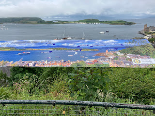
I was fascinated by the building that overlooked the town. See that above all the buildings is this Colosseum-like building.So before going onward (it was another overnight stay, wish we could have stayed another day) we had to go any investigate. Up some very narrow roads we reached this building and the park around it. It’s called McCaig’s Tower as a memorial to the McCaig family and is a spectacular viewpoint.There was a map to point out the islands
Looking post the town towards the islands
Looking left towards the station and ferry terminal.
So there will be a part 4 (gosh, I have gone on a bit!) and that will come along soon.


No comments:
Post a Comment
Thank you for leaving a comment, I will reply back by e-mail. Do come and visit again!